
The Technology Behind GNSS-Based Electronic Road Pricing.
3 June 2022 (updated 21 August 2025)
A Brief History of Satellite-Based Tolling
Global Navigation Satellite Systems (GNSS) were first used in electronic tolling in 2001, when Switzerland introduced its Heavy Vehicle Charge (in German LSVA) to all trucks above 3.5 tons travelling on any road in the country. All Swiss trucks were equipped with an On Board Unit (OBU) that measured the distance through a connection to the tachograph, with a built-in GPS receiver used for verification of the measured distance. As described here, the Swiss Road Usage Charge (RUC) system is being upgraded with new OBUs that rely completely on GNSS, without any tachograph connection.
In 2005, Germany launched its Truck Tolling System (in German LKW Maut) for the entire motorway network of 12,000 km for all trucks above 12t. This was the first distance-based tolling system to rely on satellite positioning, using only GPS since other GNSS were not yet available. The German OBUs were connected to the tachograph as a means to verify the measurement of the distance travelled using GPS. Since the German OBUs required installation by authorized mechanics, a manual ticketing option was also provided in order for vehicles to immediately use the motorways without having to wait for an OBU to be installed.

When Slovakia started its nationwide satellite-based road pricing system in 2010, a new generation of “plug and play” OBUs were introduced that could be installed by the drivers within a few minutes. All sensors and communication modules were fully integrated into one OBU that could be easily mounted on the windshields of trucks and buses above 3.5 tons. Unlike the truck tolling systems already operating in Germany, Austria and the Czech Republic, the Slovak distance-based charge was not limited to the motorways and expressways, but included first-class roads – which made up to 80% of the tolled road network. More on the Slovak tolling system and the updated solution that was tendered in 2022 is described here.
With the new flexibility that GNSS-based solutions provide, road pricing systems are no longer installed on specific roads. Instead, certain types vehicles (usually trucks and buses) are equipped with tolling equipment which enable tolling on any type of road category. This paradigm shift in distance-based tolling became the centerpiece of European toll systems that embraced the new satellite tolling technology: Hungary (2013), Russia (2015), Belgium (2016), the Czech Republic (2019), Bulgaria (2020), Poland (2021), and Denmark (2025).
The Difference Between GPS and GNSS
GPS, the Global Positioning System, was developed and operated by the United States Department of Defense and was fully operational by 1993. It was originally intended only for military use, but after a Russian SU-15 fighter jet shot down a commercial Boeing 747 Korean Airlines flight in 1983, killing all 269 passengers and crew, GPS was opened to civilian use. The Soviets followed with GLONASS (Global Navigation Satellite System, in Russian Глобальная навигационная спутниковая система) in 1982, reaching full constellation in 1995. With the fall of the Soviet Union, GLONASS capacity steadily declined. In 2011, GLONASS made a comeback, and was available for commercial use. The European Union’s Galileo system went live in 2016, and is the first and only GNSS operated by a civilian organization, EUSPA. The BeiDou Navigation Satellite System from China become fully operational in 2020.
Since the American GPS was the first Global Navigation Satellite Systems (GNSS) made widely available for civilian use, “GPS” has often been used as a synonym for GNSS – even today. However, virtually all location-based services used in road telematics and smartphones are now based on multi-constellation GNSS receivers. Since 2021, more than 50% of the GNSS receivers on the market can determine their position using all of the four satellite systems: GPS, Galileo, Glonass and BeiDou.
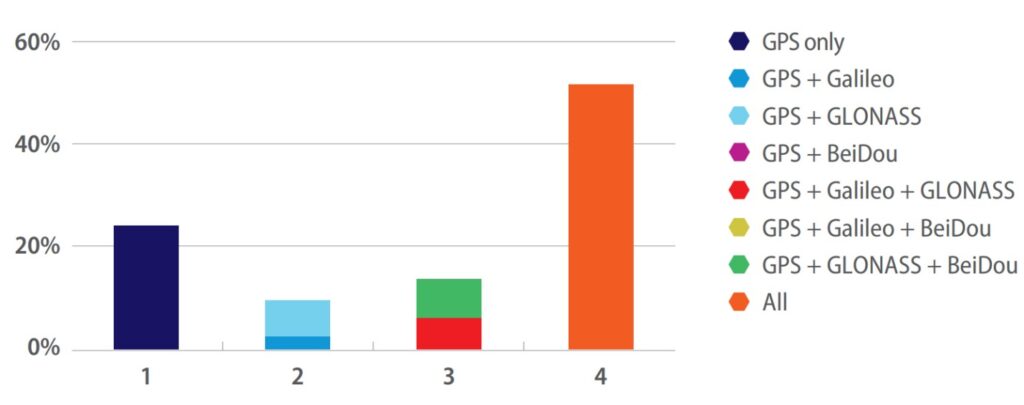
Fortunately, multi-constellation GNSS has become the de-facto standard in road telematics. Since 2021 more than 75% of all current GNSS receivers are multi-constellation with GPS typically used in combination with at least one other GNSS. As of October 2021, satellite-based on-board equipment for electronic toll systems in the European Union are required to use Galileo (based on the EU Directive 2019/520). In summary, using the term “GPS” for satellite-based navigation is both outdated and inaccurate, since it ignores the fact that other GNSS are used. The correct term for describing electronic toll systems that rely on satellite positioning is therefore GNSS-based tolling.
What started as GPS tolling is now GNSS tolling
Since their first deployment in Switzerland and Germany, GNSS OBUs have evolved considerably. European satellite-based tolling systems have focused on automotive-grade OBUs that must endure extreme temperatures and constant vibrations during travel, and should have a lifetime of at least five to ten years. OBUs should meet strict requirements defined in Service Level Agreements (SLAs) and Key Performance Indicators (KPI). National toll operators usually require that each tolled road section be recognized with an accuracy higher than 99%. Most European OBUs also use microwave Dedicated Short Range Communication (DSRC) based on the CEN-TC 278 standards which allow the OBUs to be interoperable in toll domains using microwave technology, such as Austria, France, Italy, Portugal and Spain. DSRC is also used by the enforcement systems of many toll domains so that these systems can read out data directly from the OBUs in order to determine whether they are correctly activated and are fully compliant with the toll system requirements.

With the introduction of the European Electronic Toll Service (EETS), standards have been defined which enable the interoperability between the various toll domains. Vehicles that travel through several EU countries no longer need to install a different OBU for each different toll domain, but can choose a single EETS Provider, also known as a Toll Service Provider (TSP), which provides a single contract with a single OBU that enables a vehicle to travel in any EETS domain without having to make a new registration in each individual country. An image of the OBUs provided by different TSPs that are used multiple EU member states, each having a built-in DSRC module, is illustrated here. Each of these EETS OBUs use multi-constellation GNSS which means that, at a minimum, Galileo is used in combination with GPS.
Multi-Constellation GNSS, Multi-Frequency GNSS and the Multipath Effect
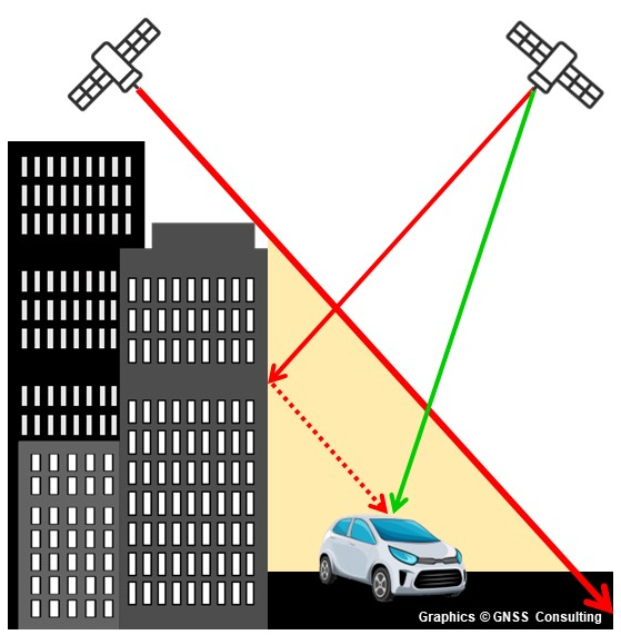
Through the use of multi-constellation GNSS receivers, the number of satellites that contribute to an OBU’s ability to determine its position coordinates is increased significantly. Since most electronic tolling schemes focus on inter-urban roads that have a clear view of the sky (and thus the satellites above), GNSS-based road pricing can be implemented relatively easily. However, using GNSS solutions for road user charging in urban environments can pose significant challenges. For satellite-based road pricing solutions to work effectively and accurately within cities and urban areas, the number of satellite signals received by an OBU is critical. Multi-constellation GNSS receivers can use any satellite signals of the systems it identifies to determine a position, but that only solves part of the problem. The other issue is the level of accuracy that can be achieved in urban canyons, in which buildings and other structures create a multipath effect, where the satellite signals are reflected and thus diminish the level of accuracy.
By using multiple frequencies of the GNSS signals (typically the L1/E1 channel in combination with the L5/E5 channel), GNSS receivers can remove ionospheric errors and mitigate multipath reflections off of urban structures. This can improve the position accuracy from 10m-15m to 2m-3m. An OBU may also use inertial navigation systems (INS), such as motion sensors (accelerometers) and rotation sensors (gyroscopes), to calculate the current position when there are either no GNSS signals (e.g. in tunnels) or not enough GNSS signals to determine an accurate position using the dead reckoning navigation technique. For sub-meter accuracy, GNSS receivers could use Real-time Kinematic Positioning (RTK) or Precise Point Positioning (PPP), although such services come at a cost and, for the purpose of distance-based road pricing, are not necessary.
Toll Data Collection in Satellite-Based Road Pricing
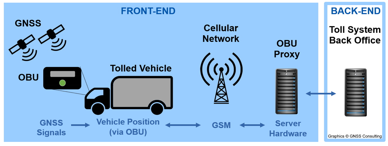
Toll Data Collection is the centerpiece of a GNSS-based electronic toll system. Although the architecture of individual systems may vary, all GNSS-based road pricing systems share common foundations in the way the operate. In a typical satellite tolling system, OBUs record the time and position data of a vehicle’s trip. This position data is stored on the OBU and transmitted via cellular (GSM) network at regular intervals to the OBU proxy (server) which processes the vehicle trip data. The actual map matching of the toll data, which determines whether the vehicle has travelled on the tolled road network, typically takes place on the proxy but can also be done on the OBU itself, when a “thick client” (or “fat client”) OBU approach is taken. The trip data is then aligned with the pricing scheme of the tolled road network from which the distance-based fee is calculated and forwarded to the Toll System Back Office, i.e. “Back End” which handles the customer accounts and billing. The “Front End” forms the core competence of the Toll Service Provider, where the OBU and the OBU proxy work together to determine the distance travelled on the tolled road network.
GNSS-Based Tolling in the United States and in Asia
Until now, there are no comparable models for large-scale satellite-based tolling schemes outside of Europe. The United States has been exploring distance-based charging for light vehicles as a supplement – and possible replacement – of the fuel tax which no longer yields sufficient funds for the development and maintenance of the public road network. Rather than mandating the use of GNSS-based OBUs for hundreds of thousands of vehicles, which is the case for each of the European truck tolling systems, the United States has been introducing distance-based road usage charging for light vehicles, with a focus on electric vehicles (EVs) and fuel-efficient cars, on a voluntary basis. Oregon, Utah and Virginia have already introduced such schemes, while 24 other states have either conducted research, executed pilots or made demonstrations of distance-based charging.
Asia is beginning to introduce satellite-based tolling as well. Singapore is currently replacing its microwave-based Electronic Road Pricing (ERP) system with a satellite based “next-generation” system (ERP-II). Indonesia has been implementing a satellite-based solution on the entire tolled motorway network. The project in Indonesia is groundbreaking since the new Multi-Lane Free Flow (MLFF) system should remove all toll plazas and use GNSS-based OBUs and smartphone apps for distance-based road user charging. India has been examining a similar approach, whereby it could replace its RFID-based FASTag system with a GNSS-based solution that will no longer require any toll plazas, thus improving traffic flow and road safely while reducing toll operation costs and fuel consumption.
Satellite-Based Tolling as one of many Vehicle Location Based Services
The advantages of using GNSS-based tolling for a comprehensive nationwide tolling scheme are indisputable. The flexibility of GNSS technology allows for all road categories to be tolled, thus making it possible to address the problem of traffic diversion and toll evasion that typically occur when only motorways and expressways are tolled. A satellite-based road pricing system can introduce a toll tariff structure that can discourage vehicles from using specific roads or entering certain zones or areas, thus minimizing the risk of traffic congestion or reducing vehicle emissions in sensitive areas such as central business districts and dense residential areas. Once satellite-based tolling solutions are widely deployed, it is only logical that additional Vehicle Location BasedServices (VLBS) will be offered in combination tolling services, such as fleet management or parking.